Widgetized Section
Go to Admin » Appearance » Widgets » and move Gabfire Widget: Social into that MastheadOverlay zone
Heavy snow is finally back in the forecast for the Vail Valley
After about a 10-day break, heavy snow is finally back in the forecast for the Vail Valley.
A couple of inches fell overnight Monday at Beaver Creek, as an up-slope storm was much kinder to Colorado’s Front Range. Resorts like Winter Park (11 inches), Eldora (7) and Steamboat (4) enjoyed a nice coating. But the really good stuff comes later this week, and it should dump up to a foot of new snow at Vail and Beaver Creek Wednesday night through Friday.

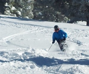
Nick Williams carves up 10 inches of fresh snow in Vail’s Montagne Glade earlier this month. Snow is back in the forecast for the Vail Valley. (David O. Williams photo).
“Heavy snow Wednesday night through Thursday (high confidence), with moderate to heavy snow also possible on Friday (lower confidence),” meteorologist Joel Gratz of Opensnow.com wrote this morning. “The bull’s eye will be the central mountains with 15-30 inches. Northern and southern areas will likely see lower but still significant totals of about a foot +/-. The best powder days will be Thursday, Friday, and perhaps Saturday morning.”
Any kind of powder day will be welcomed by local snow riders in the Vail Valley, who — after about 5 feet of fresh the first two weeks of January — have been making do with a little too much Colorado sunshine the last 10 days. Despite the picture-postcard weather, Vail and Beaver Creek have held up remarkably well and stayed somewhat soft due to continued colder temps.
Gratz adds that the longer-term forecast also looks favorable for the Vail Valley:
“The pattern between Feb 4th to 10th should bring us additional chances for snow, so it looks like the next 10-15 days will be good for our state’s water supply and our ski legs,” Gratz wrote this morning.
Avalanche danger is rated as considerable along Colorado’s Front Range, moderate in the Vail/Summit County area and moderate in the Aspen area, according to the Colorado Avalanche Information Center, but look for that to change dramatically if snowfall totals pan out from storms later this week.


